
Disclaimer: This article tries to take a neutral position. The author is aware that the discussed issues are disputed and that the information quality is not optimal. Furthermore, as the conflict is ongoing, all border changes have to be regarded as preliminary, as none of the involved governments (Ethiopia, Amhara, Tigray, and Eritrea) has officially confirmed any of them.
In my November 2020 article on Tigray’s contentious borders, I have described why many of Tigray’s borders with its neighbours, Amhara State and Eritrea, are disputed. Meanwhile, the Tigray conflict has – quite expectedly – led to a couple of preliminary border changes. They are not yet endorsed by the respective governments, but they nevertheless currently try to shape facts on the ground. Here’s my new map on the situation.
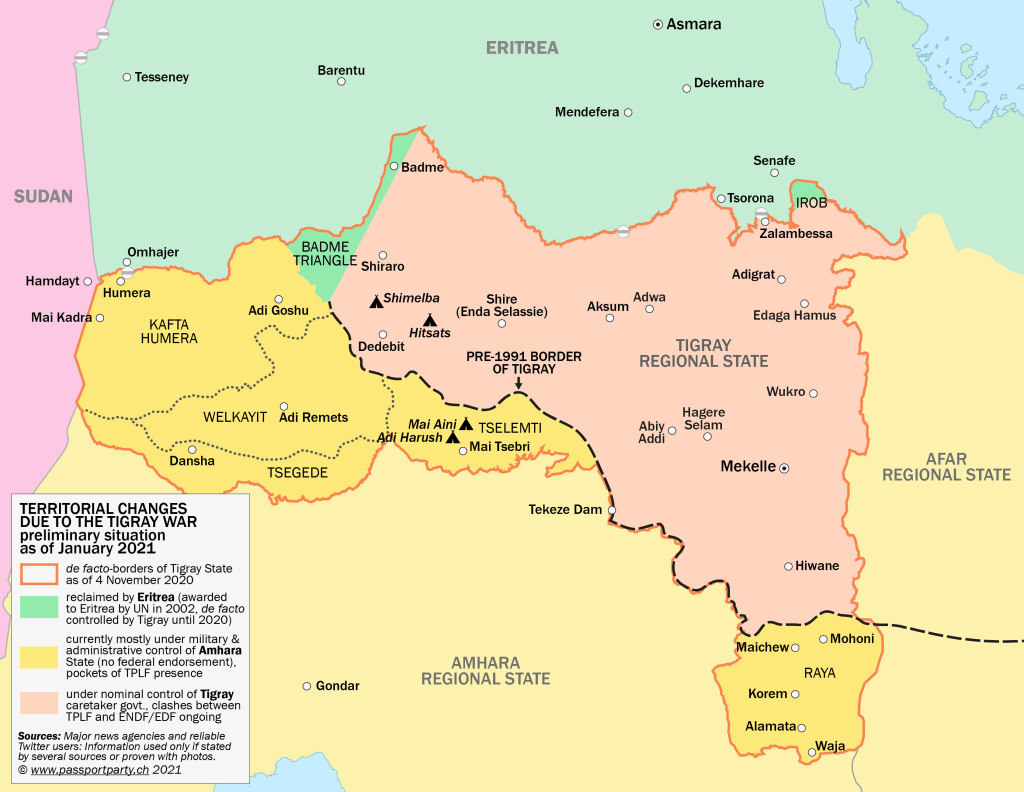
NB: This map does not show the extent of military control of Tigray’s TPLF, Amhara’s militia or the armies of Ethiopia (ENDF) and Eritrea (EDF). Information about the military front lines are extremely unreliable, as internet does not work all over Tigray since three months and just few phone lines have been reestablished. Furthermore, there is a lot of fake news and unconfirmed rumours. Hence, I do not feel competent to produce a map on the front lines. For the best approximation I know, please refer to Ethiopia Map.
Here are some details on the border changes:
Tigray-Eritrea border
The Eritrean army has most likely entered Badme Triangle already at the beginning of the war. The area has been awarded to Eritrea by a 2002 UN ruling, but Ethiopia has not returned the area since then. In December 2020, photos appeared of the Eritrean flag being hoisted in Badme. According to one source, Eritrea has meanwhile established an administration and asked the population to either accept Eritrean ID cards or leave the area. (This is a somewhat surprising information, since ID cards are currently not issued inside Eritrea proper.)
The northern part of Irob is another area awarded to Eritrea in 2002 but never handed over by Ethiopia. According to unconfirmed news, Eritrea has started to take villages of northern Irob in January 2021. Also regarding Irob, a source reports that Eritrean ID cards are being distributed.
Tigray-Amhara border
Tigray’s Western Zone (Mirabawi Zon) has been part of Amhara-dominated Begemder province prior to 1991, consisting of the regions of Wolkayit, Kafta Humera and Tsegede. In the initial phase of the conflict, Amhara militia have taken over this area together with the Ethiopian army. According to reports, the Tigrayan armed forces and administration has been expulsed, and Amhara administrations have been created in some of the towns. In Adi Remets, the main town of Wolkayit, new signs appeared which announced the town to be part of „Wolkayit Tegede Setit Humera Zone“ of Amhara state (see picture in this report). This new zone appears be the same area as Tigray’s Western Zone. However, neither the government of Amhara state nor the federal government of Ethiopia have endorsed any border changes. De facto, the region is likely to be under Amhara control.
In Raya-Rayuma area, the situation is similar. Amhara Fano militia are present, a new Amhara-dominated administration has been created. New signs claim that the main town, Alamata, is part of North Wollo Zone, Amhara state (see Tweet below). North Wollo Zone already existed before the conflict, its main town is Woldiya. Not much information on the de facto situation is available, some can be found in this report.

Dear Author
Thank you for the efforts. I think are doing a relatively good job.
One correction that is needed to done is your designation of „Badme Triangle“.
This term was extensively used during and after the 1998-2000 war. In contrast to your current map, „Badme Triangle“ is located east of the Badme town/hamlet.
Thank you
LikeLike